Search an airport
Find any airport by ICAO, IATA, city, or name and open its surface map — runways, taxiways, aprons, and terminals.
 TaxiwayClosed AI
TaxiwayClosed AI
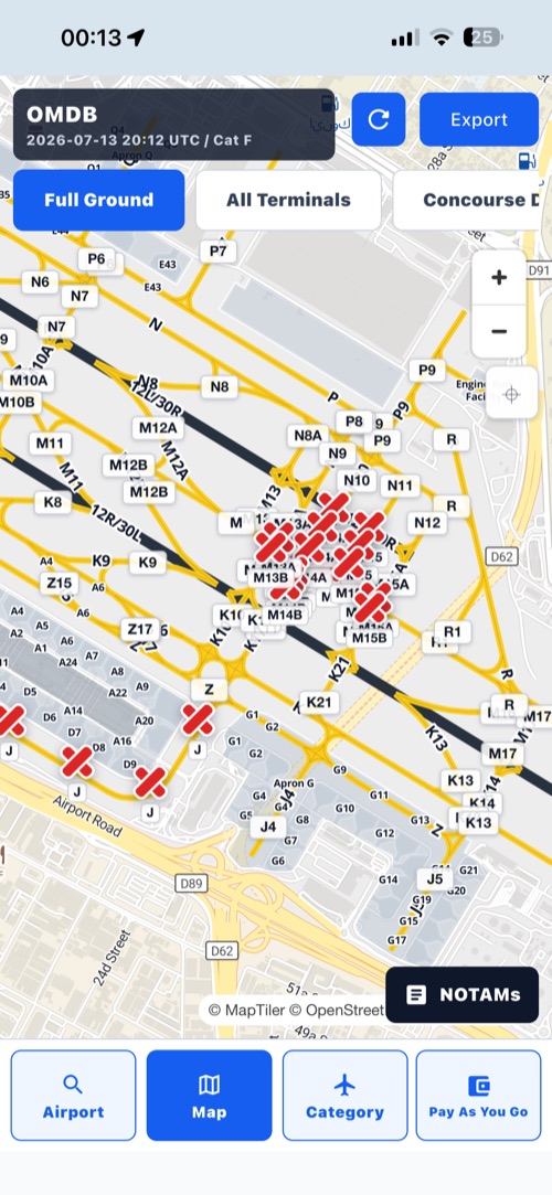
TaxiwayClosed AI reads the entire NOTAM package for pilots, then places a clear cross directly on the airport surface map exactly where a taxiway or runway is closed. One glance at the diagram shows what is closed — so flight preparation gets faster, not longer.
Awareness and training aid. Always verify official NOTAM briefings, current charts, approved EFBs, ATC, dispatch, and company procedures before any real operation.

A NOTAM (Notice to Air Missions, formerly Notice to Airmen) is a time-critical notice alerting pilots to hazards or changes — such as a closed taxiway or runway — at an airport or along a route.
In practice, a pre-flight NOTAM package can run to dozens of pages of abbreviated, all-caps text, and the one line that matters — the taxiway you were planning to use is closed tonight — is buried somewhere in the middle. TaxiwayClosed AI exists for exactly that problem: its AI agent reads the whole package, finds the surface closures, and draws a cross on the airport map where each one applies. You still read and verify the official NOTAMs from official sources; the app simply makes the closures visible at a glance, so your NOTAM review starts with a picture instead of a wall of text. Our page on the different types of NOTAMs covers the rest of the package, including the notices the agent does not mark.
Find any airport by ICAO, IATA, city, or name and open its surface map — runways, taxiways, aprons, and terminals.
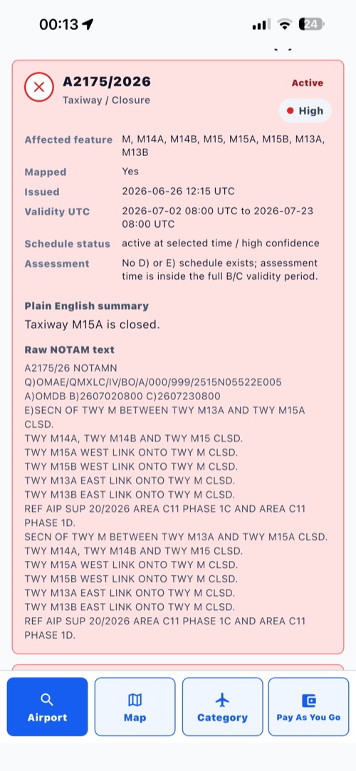
Instead of you decoding dense NOTAM text line by line, the agent works through the entire package and picks out taxiway and runway closures.
Each closure the agent maps gets a clear cross placed directly on the affected taxiway or runway, with the original text, dates, and confidence below.
Confirm everything with official NOTAM briefings, current charts, approved EFBs, ATC, dispatch, and company procedures before any real operation.
The AI agent decodes the full set of NOTAMs for your airport — not just the first page — so surface closures don't hide in the noise. See how the AI NOTAM decoder works.
Closed taxiway B between A and C? The cross sits on that segment of the airport diagram, not in a footnote. The taxiway closure map shows the idea.
One glance at the marked map tells you which taxiways and runways are affected, so flight preparation and briefing prep take minutes, not a slog through raw text.
No account, no login, no GPS tracking in the current version. Open the app, search the airport, see the closures. Website pages may use Google Analytics for aggregate traffic measurement.
| TaxiwayClosed AI is | TaxiwayClosed AI is not |
|---|---|
| An AI agent that reads the entire NOTAM package for pilots. | An official NOTAM source or briefing provider. |
| A map that marks closed taxiways and runways with a clear cross. | A flight-planning, dispatch, taxi, or navigation tool. |
| A convenient aid that makes pre-flight NOTAM review faster. | A replacement for charts, approved EFBs, ATC, or company procedures. |
| A privacy-friendly app with no account required in the current version. | A certified aviation safety or operational decision system. |
No. TaxiwayClosed AI is not an official aviation source and is not valid for flight planning, dispatch, taxi, navigation, or flight operations.
TaxiwayClosed AI is an AI agent that reads the entire NOTAM package for pilots and places a cross on the airport surface map exactly where a taxiway or runway is closed, making pre-flight NOTAM review faster and more convenient. It is an awareness and training aid, not an operational tool.
No. Always verify with official NOTAMs, charts, approved EFB sources, ATC, dispatch, company procedures, and applicable aviation authorities.
TaxiwayClosed AI may combine airport search, OpenStreetMap-based airport surface geometry, NOTAM-style information, and AI-assisted summaries. Availability, freshness, and interpretation can vary.
Confidence and mapped status are training cues about how clearly a closure item appears to match a surface feature. They are not safety determinations or operational approvals.
The current privacy policy says TaxiwayClosed does not require GPS tracking and does not track live location for advertising or user monitoring.
The current app has no registration, login, user account, or profile system.
Download TaxiwayClosed AI, see closed taxiways marked on the map in seconds, and always verify with official sources before any real-world operation.
Awareness and training aid only — not for flight planning, dispatch, taxi, navigation, or operational decisions.